Enregistrez gratuitement cette image
en 800 pixels pour usage maquette
(click droit, Enregistrer l'image sous...)
|
|
Réf : T01617
Thème :
Terre vue de l'espace - Fleuves - Rivières - Lacs (517 images)
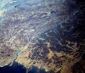
Titre : Yalu River, China and North Korea October 1993
Description : (La description de cette image n'existe qu'en anglais)
This north-looking, low-oblique photograph shows the Yalu River that forms the border between China and North Korea. The Yalu, more than 500 miles (805 kilometers) long, originates in the Changpai Mountains of China and flows southwest into Korea Bay. The river is navigable for larger vessels for almost 15 miles (24 kilometers) in the lower reaches, but only for smaller craft in other sections. Important cities at its mouth are Dandong (Chinese) and Sinuiju (Korean), both of which have sawmills and other wood-processing industries that use the timber floated downstream. The Yalu River has a hydroelectric power potential estimated at 1.5 million kilowatts. The Shuifeng Dam on the Yalu (near center of photograph) above the city of Sinuiju is one of the largest dams in Asia. Manchuria’s need for hydroelectric power in the early 1950s might have been a reason for Chinese Communist troops entering the Korean War when United Nations troops reached the Yalu. Construction of electric power facilities in Manchuria since the late 1950s has lessened the importance of the Yalu’s power plants to China.
|
|

